landschaftsfotos.eu Linie landschaftsfotos.eu
Hello guest, you are not logged in. Log in | Create account 
Forum   Contact   Legal notice
German English 

Photos by Hans Christian Davidsen

4155 Photos
The cliff coast at Wittenbeck between Kühlungsborn East and Heiligendamm. Photo taken on June 6, 2025.
Hans Christian Davidsen

The cliff coast at Wittenbeck between Kühlungsborn East and Heiligendamm. Shot: June 6, 2025.
Hans Christian Davidsen

The cliff coast at Wittenbeck between Kühlungsborn East and Heiligendamm. Shot: June 6, 2025.
Hans Christian Davidsen

The cliff coast at Wittenbeck between Kühlungsborn East and Heiligendamm. Shot: June 6, 2025.
Hans Christian Davidsen

The pebble beach east of Kühlungsborn. Shot: June 6, 2025.
Hans Christian Davidsen

The sandy beach at Warnemünde. Shot: June 6, 2025.
Hans Christian Davidsen

Blue sky over the very wide sandy beach on the Danish Wadden Sea island of Rømø (German Röm). Photo taken: May 19, 2025.
Hans Christian Davidsen

D䮥mark / S�mark / Roemoe

161 1200x800 Px, 20.05.2025

On the Danish North Sea island of Rømø (Danish Rømø), it is permitted to drive cars on the very wide sandy beaches.  
Photo taken: May 19, 2025.
On the Danish North Sea island of Rømø (Danish Rømø), it is permitted to drive cars on the very wide sandy beaches. Photo taken: May 19, 2025.
Hans Christian Davidsen

D䮥mark / S�mark / Roemoe

164 1200x800 Px, 20.05.2025

Rapeseed field near Rømø Kirkeby on the Danish Wadden Sea island of Rømø (German Röm). Photo taken: May 19, 2025
Hans Christian Davidsen

D䮥mark / S�mark / Roemoe

182 1200x800 Px, 20.05.2025

View of the Alssund in Sønderborg in a northern direction. The bridge crossing the sound is called the Alssund Bridge and connects Sundewitt (Sundeved) with the island of Als. - Photo taken on May 17, 2025.
Hans Christian Davidsen

D䮥mark / S�mark / Sonderborg

179 1200x800 Px, 18.05.2025

View from the observation platform at Tanenwai towards Norddorf on the North Frisian Wadden Sea island of Amrum. Photo taken: May 6, 2025.
Hans Christian Davidsen

Deutschland / Schleswig-Holstein / Nordfriesische Inseln

143 1200x800 Px, 07.05.2025

Viewing platform in the Amrum dunes near Norddorf. Photo taken: May 6, 2025.
Hans Christian Davidsen

Deutschland / Schleswig-Holstein / Nordfriesische Inseln

115 1200x800 Px, 07.05.2025

Viewing platform in the Amrum dunes near Norddorf. Photo taken: May 6, 2025.
Hans Christian Davidsen

Deutschland / Schleswig-Holstein / Nordfriesische Inseln

118 1200x800 Px, 07.05.2025

View from the lighthouse on the North Frisian Wadden Sea island of Amrum. Photo taken on May 6, 2025.
Hans Christian Davidsen

Deutschland / Schleswig-Holstein / Nordfriesische Inseln

129 1200x800 Px, 07.05.2025

View from the lighthouse on Amrum towards Kniepsand and the North Sea. Photo taken on May 6, 2025.
Hans Christian Davidsen

Deutschland / Schleswig-Holstein / Nordfriesische Inseln

124 1200x800 Px, 07.05.2025

Beach chairs on the Kniepsand on the North Sea island of Amrum. The Kniepsand forms a seemingly belonging to Amrum, 15-kilometer-long and up to 1.5-kilometer-wide sandy beach, which lies off the entire west coast of the island and directly transitions into the sand dunes that actually belong to the island. Photo taken: May 6, 2025.
Hans Christian Davidsen

Deutschland / Schleswig-Holstein / Nordfriesische Inseln

126 1200x800 Px, 07.05.2025

The Kniepsand serves as the beach of the island of Amrum. There are several supervised swimming beaches and nudist sections. Photo taken on May 6, 2025.
Hans Christian Davidsen

Deutschland / Schleswig-Holstein / Nordfriesische Inseln

111 1200x800 Px, 07.05.2025

View from the lighthouse on Amrum towards Kniepsand and the North Sea. Photo taken on May 6, 2025.
Hans Christian Davidsen

Deutschland / Schleswig-Holstein / Nordfriesische Inseln

108 1200x800 Px, 07.05.2025

View from the lighthouse on Amrum towards Kniepsand and the North Sea. Shot: May 6, 2025.
Hans Christian Davidsen

Deutschland / Schleswig-Holstein / Nordfriesische Inseln

112 1200x800 Px, 07.05.2025

View of the Amrum dunes from the lighthouse of the North Sea island. Photo taken on May 6, 2025.
Hans Christian Davidsen

Deutschland / Schleswig-Holstein / Nordfriesische Inseln

114 1200x800 Px, 07.05.2025

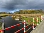
The Königsaus as seen from the Frihedsbroen (German  Freedom Bridge ). The view is directed towards the west.
Shot: October 11, 2024:
The Königsaus as seen from the Frihedsbroen (German "Freedom Bridge"). The view is directed towards the west. Shot: October 11, 2024:
Hans Christian Davidsen

D䮥mark / J�nd / Sydjylland

182 1200x900 Px, 12.10.2024

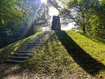
When Denmark had to cede North Schleswig to Prussia in 1864, the Königsau (Danish Kongeåen) became the state border. From Skibelund Krat, one could look south over the North Schleswig landscape. Especially farmers and schoolteachers made Skibelund Krat a national meeting place for Danish-minded people north and south of the border.  
Photo taken: October 11, 2024.
When Denmark had to cede North Schleswig to Prussia in 1864, the Königsau (Danish Kongeåen) became the state border. From Skibelund Krat, one could look south over the North Schleswig landscape. Especially farmers and schoolteachers made Skibelund Krat a national meeting place for Danish-minded people north and south of the border. Photo taken: October 11, 2024.
Hans Christian Davidsen

D䮥mark / J�nd / Sydjylland

162 1200x900 Px, 12.10.2024

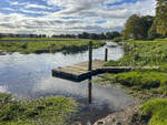
The Königsau at Foldingbro. Along the river course of the Kongeå, a hiking trail (Danish Kongeåstien) has been established. The Kongeå hiking trail is a simple footpath, but it is clearly marked with posts, so you cannot get lost. The hiking trail is a total of 67 kilometers long and equipped with information boards at interesting points. A total of 14 route sections are described in detail. Simple wooden shelters along the way can be used for overnight stays.  
Photo taken: October 11, 2024.
The Königsau at Foldingbro. Along the river course of the Kongeå, a hiking trail (Danish Kongeåstien) has been established. The Kongeå hiking trail is a simple footpath, but it is clearly marked with posts, so you cannot get lost. The hiking trail is a total of 67 kilometers long and equipped with information boards at interesting points. A total of 14 route sections are described in detail. Simple wooden shelters along the way can be used for overnight stays. Photo taken: October 11, 2024.
Hans Christian Davidsen

D䮥mark / J�nd / Sydjylland

169 1200x900 Px, 12.10.2024

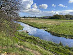
The Königsau near Foldingbro. The Au is a 65-kilometer-long watercourse that flows from east to west through South Jutland and forms the historical border between North Schleswig and the Kingdom of Denmark.  
Shot: October 11, 2024.
The Königsau near Foldingbro. The Au is a 65-kilometer-long watercourse that flows from east to west through South Jutland and forms the historical border between North Schleswig and the Kingdom of Denmark. Shot: October 11, 2024.
Hans Christian Davidsen

D䮥mark / J�nd / Sydjylland

188 1200x900 Px, 12.10.2024