




Mýrdalshreppur photos
3 Photos
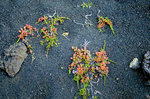
Island / Regionen / S�nd - Suand
451 1200x795 Px, 04.06.2016
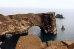
This natural rock arch gave the Dyrholaey Peninsula (literally "door hole island") its name, island because it only became a peninsula after a volcanic eruption. This coast is notorious for its storms; 100 years ago, many fishing boats sank here, with most fishermen losing their lives.
Günther Glauz†
Günther Glauz†
Island / Regionen / S�nd - Suand
1093 800x535 Px, 24.02.2007
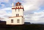
Lighthouse from 1910 on the Dyrholaey Peninsula in June 1997, 6 km west of Vik i Myrdal, the plateau is 120 m high, it drops vertically to the sea and is the southernmost point of Iceland.
Günther Glauz†
Günther Glauz†
Island / Regionen / S�nd - Suand
1091 800x547 Px, 24.02.2007