




Klostertal-Weg, Kelheim Karte Landschaftsfotos (Landschaften, Natur und Ausblicke)
6 Photos
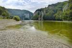
The Danube Gorge near Weltenburg. The breakthrough valley is bordered by rock walls up to 80 meters high, containing numerous smaller caves. Between the so-called Silent Wall and the Long Wall, the river narrows to just 110 meters and reaches a water depth of 20 meters. Photo taken: July 2008.
Hans Christian Davidsen
Hans Christian Davidsen
Germany / Bavaria / Lower Bavaria
595 1200x797 Px, 20.10.2015
Germany / Bavaria / Lower Bavaria
417 1200x797 Px, 16.10.2015
Germany / Bavaria / Lower Bavaria
543 1200x793 Px, 16.10.2015
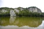
The Danube Gorge near Weltenburg is a nature reserve in the Lower Bavarian district of Kelheim. Photo: July 2008. The area is officially called Weltenburger Enge. The limestone formations bear imaginative names such as The Three Hostile Brothers, Robber Rock, Kuchelfelsen, Petrified Virgin, Bavarian Lion, Bishop's Mitre, Two Kissing Each Other, Roman Rock, Peter and Paul, Beehive (a stone with cavities like honeycombs), Napoleon's Travel Case (which, according to legend, he supposedly forgot during his retreat).
Hans Christian Davidsen
Hans Christian Davidsen
Germany / Bavaria / Lower Bavaria
579 1200x797 Px, 16.10.2015
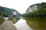
The Danube Breakthrough is a nature reserve near Weltenburg. The gorge is bordered by rock walls up to 80 meters high. Photo: July 2008.
Hans Christian Davidsen
Hans Christian Davidsen
Germany / Bavaria / Lower Bavaria
479 1200x797 Px, 16.10.2015

Danube Gorge near Kelheim in Bavaria 2011 no idea if Middle Franconia is correct.... :-)
Jan Schneider
Jan Schneider
Germany / Bavaria / Middle Franconia
1399 1024x693 Px, 10.02.2012